The field crew unspools a 48-channel geophone cable across the flat Fraser River delta plain, coupling each sensor firmly into the silty clay that underlies much of Delta BC. A sledgehammer strike on a steel plate sends a compression wave through the saturated alluvial sediments, and the seismograph records arrival times with microsecond precision. This is the opening sequence of a seismic tomography survey — a technique that generates a 2D or 3D velocity model of the subsurface by analyzing how P-waves and S-waves refract and reflect at material boundaries. In a region where the water table sits within 2 meters of the surface and Holocene deposits reach depths exceeding 300 meters, understanding the velocity structure is critical for evaluating liquefaction potential and seismic site response under NBCC 2020 provisions. The survey lines are laid out along road shoulders and agricultural access tracks, carefully avoiding buried utilities and drainage culverts typical of the municipality.
In Delta BC, peat lenses within the silty clay sequence can cause abrupt velocity reversals that require combined refraction-reflection inversion to resolve hidden-layer ambiguity.
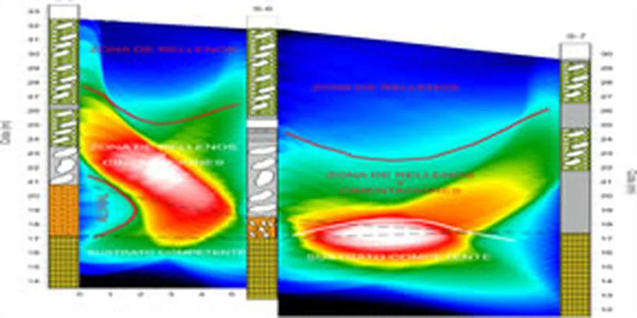
Methodology applied in Delta BC
Demonstration video
Local geotechnical conditions in Delta BC
A common oversight in Delta BC is assuming that seismic refraction alone will capture the low-velocity peat layers that dominate the upper 10 meters. When constructors rely on a single refraction profile and the inversion algorithm assumes a simple three-layer model, the peat lens is either smeared into an unrealistically thick intermediate layer or missed entirely. The consequence is an overestimated V s30 and an incorrect NBCC site class assignment — potentially leading to under-designed foundations for schools, fire halls, or multi-family residential buildings on the delta. Pairing refraction with reflection processing isolates those low-velocity zones and produces a velocity model that matches the actual stratigraphy encountered during borehole drilling.
Our services
Our seismic tomography services in Delta BC are structured to address the specific challenges of the Fraser River delta stratigraphy. Each survey is customized to the project scale and target depth.
2D Seismic Refraction Tomography
Multi-channel refraction survey with non-linear travel-time inversion for Vp models down to 80 meters. Ideal for seismic site classification, rippability assessments, and bedrock mapping beneath the delta sediments.
Shallow Seismic Reflection Profiling
Frequently asked questions
What is the difference between refraction and reflection tomography?
Refraction tomography uses first-arrival travel times of critically refracted waves to build a velocity model that increases with depth, ideal for general site classification. Reflection tomography processes later-arriving energy reflected from layer boundaries, producing a structural image of interfaces such as peat-till contacts. Combining both methods on the same dataset gives both velocity and geometry information, which is particularly useful in Delta BC where low-velocity peat layers sit above stiffer till.
How does seismic tomography help with NBCC 2020 site classification?
NBCC 2020 assigns site classes A through F based on the average shear-wave velocity in the top 30 meters (V s30). Seismic tomography provides P-wave velocities that can be converted to S-wave velocities using empirical relationships (e.g., V s = V p / 2.0 for saturated sands). The resulting V s30 profile directly determines the site class and the corresponding seismic hazard amplification factors used in structural design.
What are the typical costs for a seismic tomography survey in Delta BC?
A standard 48-channel refraction-reflection survey covering a 200-meter line typically ranges between CA$3,160 and CA$7,060, including field acquisition, processing, and a report with interpreted velocity models. Costs vary with line length, access conditions, and the need for additional borehole calibration. Contact us for a project-specific quote.
Can seismic tomography detect peat layers in the Fraser River delta?
Yes, but only when reflection processing is included. Refraction alone struggles because peat has a lower seismic velocity than the overlying silt, creating a hidden layer that the refraction inversion cannot resolve. Reflection imaging captures the top and bottom of the peat lens as distinct reflectors, and the velocity model from refraction can then be constrained to match those depths. This combined approach is standard practice for Delta BC sites underlain by organic deposits.