Following ASTM G57-06 and the BC Building Code (Section 4.2), electrical resistivity surveys are the go-to method for mapping subsurface layers without drilling. In Delta BC, where the Fraser River delta deposits create thick sequences of silts, sands, and peat, resistivity data helps us distinguish aquifer boundaries from clay-rich aquitards before we move to more invasive methods like MASW / Vs30 testing or CPT. The technique is particularly effective here because the contrast between saltwater-influenced sediments and freshwater zones yields strong resistivity anomalies, making the interpretation much more reliable than in uniform glaciated till.
Resistivity surveys in Delta BC routinely detect the transition between peat and marine clay at depths critical for foundation design, reducing drilling costs by up to 40%.
Methodology applied in Delta BC
Local geotechnical conditions in Delta BC
The seasonal flooding risk in Delta BC means that shallow groundwater is a constant variable. During wet months, the resistivity of the top 5 m can drop by 30% due to increased pore-water salinity from agricultural runoff and tidal influence. If you run a resistivity survey in July and another in December, the apparent resistivities will differ enough to change the interpreted layer boundaries. We account for this by measuring soil temperature and pore-water conductivity at the same time as the geophysical survey, and we calibrate the inversion model using at least one borehole per site. Without that calibration, you risk misidentifying a clay layer as silt or vice versa, which can lead to underestimating foundation settlements.
Our services
We offer a full range of resistivity-based services tailored to the geological conditions of Delta BC.
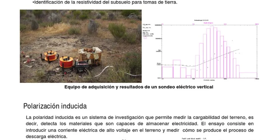
Vertical Electrical Sounding (VES) for Stratigraphy
1D resistivity soundings using Schlumberger arrays to map layer thicknesses, identify aquifers, and detect saline intrusion. Typical depth range 5–60 m.
2D Electrical Resistivity Tomography (ERT)
Multi-electrode surveys producing cross-sectional images of the subsurface. Ideal for mapping buried channels, landfill boundaries, and contamination plumes.
Corrosion Potential Assessment
Resistivity measurements combined with pH, redox potential, and sulfate content to evaluate soil corrosivity for buried pipelines and foundations. Meets ASTM G57 and NACE SP0169.
Frequently asked questions
How deep can a VES survey reach in Delta BC?
With a 300 m spread using a Schlumberger array, we can resolve layers down to about 60 m depth in the conductive deltaic sediments. In areas with thick peat, the maximum depth may reduce to 40 m due to signal attenuation.
What is the cost of an electrical resistivity survey in Delta BC?
For a typical residential lot requiring 5 VES points, the cost ranges between CA$970 and CA$1,360. Larger commercial projects with 2D ERT lines run higher depending on line length and site access.
Can resistivity testing find groundwater contamination?
Yes. The resistivity contrast between fresh groundwater and saline or hydrocarbon-contaminated water is significant. We routinely detect leachate plumes and saltwater intrusion in Delta BC using 2D ERT arrays.
Do I need a permit to run resistivity surveys in Delta BC?
No drilling permit is required for surface geophysics. However, if you need to place electrodes in road rights-of-way or parkland, you must obtain a temporary work permit from the City of Delta's engineering department.
How do resistivity results compare to borehole data?
Resistivity models are calibrated against borehole logs. The correlation is excellent for identifying layer boundaries and groundwater zones, but resistivity cannot replace direct sampling for strength parameters. We always recommend combining VES with at least one borehole per site.