The contrast between the flat, deltaic deposits in the Burns Bog area and the steeper terrain near Boundary Bay highlights why landslide assessment in Delta BC requires a differentiated approach. We have seen developments on the natural levees of the Fraser River suffer from differential settlement that later triggered shallow translational failures, while sites on the peat-rich organic soils of the bog face entirely different rotational instability mechanisms. Before any grading permit is issued, we recommend complementing the analysis with a study of organic soils to account for the compressibility of the fibrous peat layers that can act as weak basal planes. Each sector of Delta BC demands a tailored field investigation, from borehole logging to slope inclinometer installation, to capture the spatial variability of the subsurface.
A factor of safety below 1.3 under static conditions in Delta BC demands immediate mitigation, as the clay-silt sequence loses strength rapidly under sustained rainfall.
Methodology applied in Delta BC
Local geotechnical conditions in Delta BC
A recurring mistake we see among developers in Delta BC is relying solely on shallow test pits to assess slope stability. The peat and soft clay layers that dominate the subsurface can mask a deeper weak zone that only becomes apparent after heavy rainfall or seismic loading. Without a proper landslide assessment that includes continuous sampling and piezometer installation, the design may miss the real failure plane. This oversight leads to the all-too-common scenario where a retaining wall designed for 2 m of active pressure fails because the actual slip surface runs 4 m below grade through a pre-existing shear zone. We have documented cases in the Ladner area where post-construction monitoring revealed progressive creep rates of 5 mm per year, a sign that the initial assessment underestimated the long-term strength degradation of the clay.
Our services
Our landslide assessment in Delta BC is structured around four complementary services that cover the entire workflow from field investigation to final recommendation.
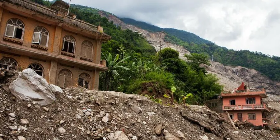
Reconnaissance and Hazard Zonation
Visual inspection of the site, review of historical aerial photos, and mapping of existing tension cracks, scarps, or displaced fences. We classify the landslide hazard level according to the BC Ministry of Forests guidelines.
Subsurface Investigation and Sampling
Borehole drilling with continuous Shelby tube sampling in clay layers, SPT in sand/silt horizons, and installation of standpipe piezometers to monitor groundwater fluctuations over a full seasonal cycle.
Slope Stability Modeling
2D limit equilibrium analysis using SLIDE software. We run both static and pseudo-static scenarios with NBCC 2020 seismic coefficients, and produce factor of safety contours for multiple trial failure surfaces.
Mitigation Design and Monitoring
Recommendations for surface drainage, subsurface drains, soil nailing, or anchored retaining walls. We also design a monitoring plan using slope inclinometers and crack gauges to verify performance post-construction.
Frequently asked questions
What is the typical cost range for a landslide assessment in Delta BC?
The cost for a professional landslide assessment in Delta BC generally falls between CA$1.550 and CA$4.760, depending on the site complexity, number of boreholes, and the depth of investigation required. This range covers the field program, laboratory testing, and the final report with stability analysis.
How deep should boreholes be for a reliable slope stability analysis in Delta BC?
We recommend boreholes extending at least 1.5 times the estimated height of the slope, but never less than 10 m in Delta BC due to the thick sequence of soft clay and peat. This depth ensures we intersect any deep-seated failure surface that may form in the underlying silt layer.
What factors of safety does the NBCC require for slopes in Delta BC?
The NBCC 2020 does not prescribe a specific factor of safety for slopes, but the geotechnical community in BC generally requires a minimum of 1.5 under static long-term conditions and 1.1 under seismic loading. For temporary slopes during construction, a factor of 1.3 is often accepted.